About the Boonslick
Geographic
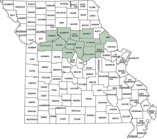
The accepted definition of the Boonslick Region seems to include an area extending from Danville in Montgomery County on the east side of the state to Lafayette County on the west, and from counties along the Missouri River (Callaway, Boone, Howard, Cooper, Saline) north to Carroll, Chariton, Randolph, Monroe, Audrain, and Pike. The historical Boone’s Lick Road led from St. Louis/St. Charles westward to Old Franklin, and was the forerunner of the Santa Fé Trail.
The Boone’s Lick Region History
Missouri’s Civil War
Missouri achieved statehood in 1821 as a result of the famous “Missouri Compromise.” It was decreed that Missouri be admitted as a slave state, but thereafter no state north of the 36° 30′ North latitude in the Louisiana Territory would be permitted to harbor the institution.” The Compromise left an uneasy equilibrium that kept the country together until the troubles in Kansas began in the 1850′s.
The first consequence of Missouri’s admission as a slave state was a flood of immigration by people Southern heritage, from states such as Tennessee, Kentucky and Virginia. Southerners, like Easterners, were on the move westward in the first half of the nineteenth century. Many of these new Missourians located in the fertile Missouri River Valley; Some brought slaves, and many others who did not own slaves brought with them a tolerance for the slave culture.
The area of central Missouri having the highest proportion of slave-holders came to be known as “Boonslick”. The boundaries of this territory are subject to conjecture, then as now, but in this part of Missouri the boundary can be laid out along the deep valley of the Loutre River that exists 2½ miles west of here. This natural barrier, the existence of German settlements centered at Hermann, only 15 miles to the south, and of a railroad tying commerce to St. Louis, just to the east, would turn Danville into a no-man’s land by the end of the Civil War.
The Boonslick was isolated from the rest of the slave-holding South by the mountain region known as the Ozark plateau, where (as elsewhere in the South) the slave culture did not take root. Even as the 1860′s arrived, transportation of goods and agriculture products in and out of the Boonslick depended inordinately on steamboats plying the Missouri and Mississippi Rivers. St. Louis, by then a manufacturing center with a large proportion of European immigrant labor, stood squarely between the Boonslick and the rest of the slave-holding South.
In 1861, the area we now know as “Little Dixie” – the Boonslick – was the northernmost pocket of Southern and slave-holding sympathies in all of the United States. By early 1862, the Confederacy lost any opportunity it ever had to control the Boonslick by force of arms, and regular Confederate armies were operating out of Arkansas. It was simple geography and some say a heavy-handed military administration of the population sympathetic to Southern views, and that brought about the fierce guerrilla civil forces warfare, practiced by both sides, that most people associate with Missouri’s Civil War.
All of these factors helped to bring about Danville’s date with destiny, October 14, 1864.
The Boonslick Today
The historic Boonslick region today reflects a rich mixture of its agricultural roots with educational and cultural activities to draw the attention of the entire Midwest. At the center is the growing urban area of Columbia, home of the University of Missouri, the first land-grant institution west of the Mississippi River. Festivals, art shows and farmers markets draw visitors from around the state to Columbia, which has also become a regional shopping hub. Rocheport, Boonville and Fayette to the west and northwest each offer unique attraction for history-minded visitors, as do Centralia and Fulton to the northeast and east.
The Boone’s Lick Road
In 1799, Daniel and Rebecca Boone moved from Kentucky and established a home in St. Charles County, Missouri. Their grown sons, Nathan and Daniel Morgan Boone, emigrated with them. Two sources of salt were discovered to the west, north of the Missouri River – “salt licks”, which referred to the practice of wild game to lick salt deposits appearing at the ground surface. One of these sources was acquired by the Boone brothers, and hence was known as Boone’s Lick, located in Howard County. The road which connected St. Charles to these sources became the Boonslick Road. Later, the entire region that straddled the Missouri River came to be known as the Boonslick. Now, it is better known as Missouri’s “Little Dixie.”
The Boonslick Road originally ended in Howard County, Missouri, where the Boones’ salt works is now a Missouri State Historic Site. After this road was extended westward from Howard County, the old Boonslick Road would become the Santa Fe Trail. This ancient thoroughfare later became U.S. Highway 40 and finally modern Interstate 70.
Sources
- Missouri’s Civil War Heritage Foundation, Inc.
- William Fischer, Jr., of Fort Scott, Kansas
- Don B. Cullimore of Fayette, Missouri